
The Newfoundland T’Railway is a 900 km long linear provincial park, stretching from St. John’s in the east to Port-aux-Basques in the west. The notion of riding it has long been on my mind and this year I attempted and completed it.

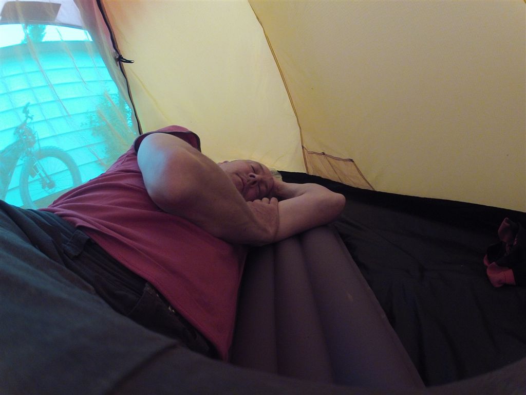
The beginning.
The stats
The route is 900 km long.
I completed it in ten days.
Riding west to east was a good decision – I had tailwinds on 7 or 8 days out of ten.
I had one day of rain.
I saw lots of ATV’s and zero cyclists, zero hikers.
I saw no moose but lots of other wildlife sightings (see below).
Traveling time ranged from 8 – 12 hours per day. The rest of the time I was doing this.
The gear
I used a Surly Pugsley for this trip set up in a bikepacking mode and in my not so humble opinion it was the perfect bike and set up for the trip. The big tires provided cushioning against the uneven surface and float when the ballast got deep and loose. Bikepacking mode kept the overall weight low.
The scenery
As predicted the section from Port-aux-Basques to Badger was the most scenic. Central NF (Badger to Terra Nova Nat’l Park) was mostly boreal forest – the good news is that the trail in this area is in good shape and you can make good time. From Terra Nova to St. John’s there is a great mixture of scenery.

I camped on this beach the night I arrived in Port-aux-Basques.

Start my trip with some beach riding? Yes please!

Cape Ray.

Codroy Valley.

My campsite on Georges Lake.

You see a number of old rail cars converted to cabins along the way but this was the best.

Taking refuge on the only day of rain.

The Gaff Topsails are stark and desolate.


A granite quarry in The Gaff.

The view from a campsite in Central.


The pitcher plant, our provincial flower. It thrives in bogs and is carnivorous – how appropriate.

Near Terra Nova.

A statue of infamous premier Joey Smallwood – half Stalin, half Buddy Holly. In Gambo.

Along the isthmus.

In Avondale you will see the only remaining section of rail line.

As you approach St. John’s there is a lovely section that follows Conception Bay.

Bridges

St. Fintan’s.


Robinsons.

Fischell’s Brook.


The longest bridge is this one at Bishop Falls.
Maps
All I used was a free road map from NL Tourism. It shows a thin red line for the T’Railway and that was enough to navigate the whole route.

Click on image to enlarge.
One of the best things I did was copy and paste a distance table from the T’Railway web site. This was invaluable for planning throughout the day where I might get food, might think about setting for a target for the day, etc. I referred to it often.

The table I took from the T’Railway website. It tells you the distance between towns and the remaining distance to St. John’s. I taped it on with packing tape.
People
As always on adventures, meeting people is a highlight, and an especially welcome break from yourself when traveling solo. I met two couples on ATV’s on the west coast who offered me cookies and a can of pop, another couple on an ATV who stopped and asked “Is that a Pugsley?” (I just about shit) and offered me a place to stay if needed in Grand Falls, and a mountain biker in Deer Lake who was all jazzed about my bike and what I was doing, to name just a few.

These kind proprietors filled my water bottles with ice.


I met the Calnen brothers, who were from Nova Scotia. They come over every year because Newfoundland is so ATV friendly.
The trail
The condition of the trail was good. The roughest section was in the Gaff Topsails which are the most remote section of the trail and the section that gets the worst weather. The only time I dropped my tire pressure was in this section as there were a lot of “baby heads” and I was bouncing a bit. The trail was in its best shape in Central and approaching St. John’s, where you could easily ride a road bike.


There were a few times when I could ride beaches instead of the rail bed, like this section near Stephenville Crossing.

It was heaven compared to the rough surface of the trail!

You ride until you come to this bridge; cross under it, come out the other side and head for the road bridge because…

…this bridge is closed.

Though the rail line crossed the top of the Main Dam in Deer Lake users are now rerouted below it.

I took every opportunity I could to take a dip. Near Howley.

The only day of rain was in the Gaff Topsails. Note the water on the trail. A lot of days like this would be really unpleasant.

The high point on the trail is in The Gaff. Mile 328 refers to the distance from St. John’s.

Signage overall is lacking; it is at its best in Central.

The trail often crosses the Trans-Canada Highway – where it does tunnels have been put in place. They are a great place to take shelter from the sun or rain.

In St. John’s the trail runs parallel to some major streets…

…but just as quickly you are back into sections where you wouldn’t know you were in a capital city.

The railway station is the green roofed building and the end of the trip for me.
Food and fuel
Access to stores occurred every day. Most communities have a small convenience store where you can get a least the usually array of junk food; I was able to get bananas, for example, most days. For those of you not from Newfoundland convenience stores here also sell beer, and if you are really lucky they may also have a Liquor Express so you can get wine and distilled spirits as well. Also, fuel for alcohol stoves was readily available in most of these stores as well – it is sold as gas line antifreeze, about $1.60 for 150ml (three good burns). Canisters and white gas were available in the major centers (Corner Brook, Grand Falls, Gander).

I couldn’t wait to eat these again. They are called “Scramblers” and they are available at Karl’s Konvenience in Stephenville Crossing, right next to the T’Railway. They are tart shells filled with egg, onion, green pepper, cheese and topped with bacon! I ate two there and bought two more for the road – just $1.50 each.

You MUST go into this store in Howley. It has been years since I’ve seen a general store like this. They have EVERYTHING!

Be sure to stop at Chestnut Tree Cafe when passing through Gambo.

I ate a lot of wraps with peanut butter.
Critters
I saw no moose for the entire ride but did see rabbits, grouse, spawning salmon, fox, caribou and beavers.

A beaver patrolling the pond.

This beaver dam interrupted the entire trail!

My best wildlife encounter was when I came upon this family of foxes…

…Dad approaches…

…pisses on a plant…

…and then walks by me with a look that implied “And I’ll piss on you if you mess with my family!”

I also enjoyed watching this beaver for the longest time…

…and then it was joined by another!

Spot the grouse.
A true friend

Nancy E was kind enough to meet me at the end of the trip with a cold beer and to snap this picture of me.
ADDENDUM
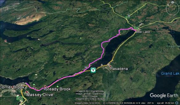
I failed to point out when I posted this a few years ago that I got from Corner Brook to Deer Lake by staying off (mostly) the Trans-Canada Highway. Leave Corner Brook via Riverside Drive. This will take you to the highway, which you will have to ride on for 3 km until you get to Steady Brook. In Steady Brook get on Marble Drive and head east until it ends at a farm on your left. Follow the easement through the farm to Strawberry Hill Lodge. Cross under the highway to Johnson Drive, then turn left on Bonnell Drive. Cross under highway again then cross river into Humber Resort. Follow Lakeside Drive until it ends. Bear right and then start using Google Earth or whatever you use/have to negotiate the woods roads on the north side of Deer Lake to the town of Deer Lake.

Excellent journal of a lovely trip across the island. Quite an accomplishment!
Thanks Garry.
Excellent a great adventure enjoyed photos and blog.
Keith Brown
Butter Pot Park
Thank you Keith.
hi great pics n a great trip
Hey Malcolm,
Right tool for the job, the pugsley. Looked like just a great trip! Love this: “half Stalin, half Buddy Holly”
Guy
Thanks Guy.
What a great ride. Fab pictures too. Very envious. Have forwarded the fb link to some pugsley riders in Scotland. Are you on twitter?
Thanks Sara. Sorry, not on Twitter.
What a great post for what must have been a super trip. I would love to do something like that. What’s next . . . retracing the route of Wallace & Hubbard?
Don’t be putting ideas like that in my head, Loyal! Thanks for reading.
Excellent, we are big rail trail fans, and I have this one on my list for a family ride one summer. I hadn’t heard of anyone doing the whole trail by bike. Was the ATV traffic enough to make you nervous or just a few per day?
Hi Doug,
Read about your recent adventure on Vik’s blog (see: http://www.vikapproved.com/ ). The ATV traffic was just a few per day, respectful and nothing to be nervous about. If you and the family do make it out this way I’d be happy to help in any way I can.
Malcolm
Once again, you have done a superlative job recording your trip!
Thanks Jan. What with your trailway riding experience that means a lot! 😉
Way to go Malcolm. Awesome read, and an amazing ride. I would love to attempt the ride one of these days.
Thanks Mel. Hope you try it someday – it is a great way to see our province.
Epic ride – and excellent photos and commentary! Would love to do a trip like this someday.
Thanks for the kind words Megan.
Nice Malcolm! Great trip recap and I second your opinion on the Pugsley, although I question if I can ever pack as light as you.
Awesome trip and a great read….loved the pics too!!
Thanks BCD!
I hit the magnifier on the Howley shot… good ol’ apple arse! xo
ne
🙂
Enjoyed the write-up, it looks like a great trip and congrats on finishing it. Are there many routes in Newfoundland that can be ridden in the wintertime? I know some areas that have snowmobile trails don’t like having fat bikes on them. Thanks
Thanks Tom.
There are lots of places to ride here in the wintertime and there are no rules forbidding bikes from the snowmobile trails. I do realize, however, that when on snowmobile trails I am an anomaly and behave accordingly. I expect snowmobiles to be on the trails but they sure don’t expect me. I’m also cognizant I can hear them coming but they can’t hear me coming. I simply pull over and let them pass and there are no issues. I have never been treated badly by a snowmobiler but have had a lot of questions and a lot of encouragement for what I do.
In terms of snow/conditions/trails the best place is western NF, followed by central NF. Here in the east our conditions are less consistent.
Here is a link to the provincial snowmobile federation: http://nlsf.org/cms/
Thanks for the information!
Tom – if you look at the distance chart on that website (see here: http://nlsf.org/cms/PDF/TrailDistanceChart.pdf ) you can see that there are literally 1000’s of kilometers of trails here. Come on over and we’ll start knocking off a few of them. 😉
I’m drooling at the prospect of that much terrain!
Inspired by your ride/blog we did our first off-road ride ever today. Also our first ride in some time without kids attached. http://deceasedcanine.blogspot.ca/2013/08/a-birthday-ride.html
I’m flattered I was a source of inspiration for you and congratulations on your first off-road ride. I hope you enjoyed it enough to do many more. Also, Happy Birthday!
Great report. Fun to see mile zero of the Trans Canada Trail…. now I know what I am shooting for. Really itching to make that ferry trip one of these years. If you want to see what the trail looks like between where you are and where I am in Vermont – check out my ride last year (and 2009) http://audaxvermont.blogspot.com/ and photos at https://plus.google.com/u/0/photos/108377311123808474629/albums/5579898055831242865 Actually trying to extend this bikepacking route so you can ride from St John’s to NYC!!! Anyone want to race an east coast route?
Very cool what you’ve done and what you are planning to do. And you’re right, you want a Pugs for what you are doing.
Good trip report. Gives a good feel for the trail.
Got me thinking……
Pingback: Across Newfoundland by fatbike or road bike | Trails and Tours
Many Thanks for the trip report, will be doing it last August.Cheers.
Please let me know how it turned out for you!
After reading your blog a while back, I decided to tackle the T’railway myself. I ended up doing (with a friend) from Corner Brook to Grand Falls. I wanted to it it all however time did not permit. It was a great trip and something I will always remember. You are right about the Gaff Topsail! It was definitely the most challenging area but also quite amazing to ride through. Thank you for inspiring me. I would not have done it if I didn’t come across your blog. 🙂
Chris from Halifax but raised in Deer Lake Newfoundland 🙂
“Inspiration through perspiration!” – maybe that should be my new motto! Thanks for the kind words, Chris. That is a solid 200 km ride you just did. I’d love to know more: how long did it take you, what type of bike(s) did you use, advice you’d give others?…
Great read, what a tip. I’d love to do it sometime myself. Thanks for sharing!
Thanks Trevor. I hope you get the chance to do the ride. It is well worth the effort.
I did it with a friend last year and was inspired by this article. Great trip!!!
Hi Malcolm,
Are you still monitoring this blog site?
Tony
I am.
wow!! so amazing….makes me want to do this trip…from Ottawa. I think I’ll start learning how to fatbike and then get myself a trip (on my own) across this huge country of mine!! (or maybe fly there and then bike it!!)
thanks for sharing….awesome pics and story!!
Hey – my son and I are planning on making this trip this summer (august) using mountain bikes. I picked up Sue Lebrecht’s book and wondered if the trail information in her book is still accurate. The book was published in 2003 and I am wondering if you know whether the trail has been upgraded much since then… Enjoyed your post of your trip….
Yes, the trail has seen upgrades since 2003. You will see this especially in the 50 km nearest St. John’s. Also, some of the bridges have been improved as well.
Please drop a line after your trip. I’d love to hear about your experience.
Our plan is to start at port-sux-basques on august 14th and end at Argentia about 10 days later…I’ll let you know how we make out…..
At Placentia Junction you can turn right off the Trailway and follow the old Argentia branch line down to Argentia.
See: http://www.graveltravel.ca/index.php?option=com_content&view=article&id=57:the-argentia-line&catid=1:routes
Thanks for the tip about the old Argentia branch line down to Argentia….some of it looks pretty rough!
Hi
I started biking only recently but I was wondering during your trip was it difficult to find a spot to pitch a tent? In Newfoundland it seems to be quite a challenge to do.
My experience is quite the opposite. I’ve found free camping in Newfoundland to be quite easy. So much of the land is Crown land, there is lots of water available and I can often pitch my tent where there is a nice view.
Glad to hear you have recently discovered cycling. Maybe we’ll meet on the trail one day.
Well I was thinking more along the lines of finding a spot which is not a bog or a rock and is flat rather then private vs crown land. That is good to hear though that you did not have difficulties camping along the way. Thanks for your reply.
enjoyed your photos what an adventure I am too old for that now terry
Glad you enjoyed it, Terry. I hate to think anyone is too old for an adventure but I guess there will come a time when we all slow down.
Great pics , I’m planning on doing the same trip this summer on a Pugsley. What would you do different and what did you do for water ,or did you have enough for each leg of the trip? How many flats did you have and did you take an extra tire?
Glad to hear you’re going to ride the Trailway. The Pugs will be perfect.
I can’t think of anything I’d do different. In fact, I enjoyed it so much I’m going to do it again this summer, but east to west this time. On the Pugs again. 😃👍
Water is plentiful along the trail so no worries there. I did not bring a spare tire and can’t see any need for you to either. Zero flats.
Hi, I did the west to east route on the highway 40 yrs. ago. All hands tell me the hwy. is too dangerous now. As a 60th birthday gift to myself I am planning the rail route this summer, or next . I am told I should get either a pugsly or an icecream truck but the top of the line would be the E.C.R. Did you consider any of the other companies? What kind of tire did you use , and what size.
Your article here is fantastic!
Hi Robert,
I don’t think the highway is all that dangerous, but it is uninteresting. I’m certain you’ll love the ride on the Trailway.
I used the Pugsley because that is what I own. My bike has Rolling Darryl rims and I used 3.8″ Husker Du’s for tires.
My next bike will be a 29+ and I think the ECR would be an excellent bike for trans-Newfoundland.
Thanks, the homework phase begins !
Great blog post! I’m planning on doing this route next summer and wondered if you think 7-8 riding days would be too ambitious. Thanks.
Completely doable. I know two people who did it in that timeframe this past summer.
hello!
i admire you doing this kind of journey which seems very Amazing! i’d love doing something like that one day. i am a swiss amateur road biker and i’d planned very luckly a tras NFL. the way you did seems to be pretty nice but not for road bike, right? maybe mountain bike as well. great. i hope i can share one day such an experience with you and people. good job! it’s an Amazing experience and a lesson of your person! cheers from switzerland, pascal
Thank you, Pascal. The Trailway is not for a road bike, but a strong rider could do it on a mountain bike for sure. I think the best bike would be a 29+.
What about a monster cross or touring bike (i.e. Surly Cross-check)? Our group will have a variety of riders on a mix of bikes and we’re wondering if some might have issues on their touring/CX bikes. Thanks.
Monster cross, maybe; traditional touring bike – you’ll be under-gunned. There are sections of the Trailway where there is lots of loose ballast; other sections, like from Howley to Badger, the ballast has washed away and it is rough. That said, there will be much of the Trailway that can be ridden on a traditional touring bike. If that is the only bike you have then an option will be to hop on and off the Trailway, using the highways to bypass rough sections. But, if this is going to be your only crack at this ride AND you want to enjoy yourself, bring the big tires – think plus bike or fatbike.
Don’t know if you read this blog post?: https://theslowbiker.wordpress.com/2014/09/29/newfoundland-by-bicycle-a-guest-blog/
Dan and Jen covered both the roughest section of the Trailway (Howley to Badger) but also some of the smoothest (Stephenville to Corner Brook, east and west of Gander) on bikes with 2.0 and 2.2 tires. Here’s part of what they took away from their experience:
Jen ran 2.0 knobby tires while Daniel ran 2.2 knobbies. Tires with high volume but low rolling resistance worked well for our mixture of paved, dirt and gravel roads. The loose gravel sections of the T’railway were the most challenging and got us thinking of the benefits of fatbike touring. Though there is no perfect bike for this type of our, a rigid mountain bike with bikepacking bags or tight-fitting panniers would work well for most sections. As Malcolm has shown, a fatbike takes the edge off of the more gravelly sections, while less voluminous tires would make for speedier road riding.
Thinking about doing this ride in June with a couple friends. Did a trail ride from Washington DC to Pittsburgh a few years ago ( C&O Canal Towpath and Great Allegheny Passage trail : 300mi in total). I rode a hardtail with panniers. Have the option of a Fat bike (LG) but I own a Maya trailer that I can haul with the hardtail so I am tending towards this option. Had a question for you regarding camping along the trail. I prefer sleeping in a hammock rather than a tent. Is this a practical option to use here ?
You’ll be fine with a hammock. Lots of trees here, as hopefully you’ll discover.
Has this ever been done in the winter i.e. fat biking on snow?
I am assuming it would get a lot of snowmobile traffic — it would be semi-groomed. And with all the communities for re-supply and the proximity to the highway it would be easier/safe than the “Iditabike”….thoughts?
That idea has been on my radar for awhile. You are correct in assuming it gets snowmobile traffic and resupply is easy. Late February/early March would probably be the ideal start time, as days are getting longer but still lots of winter left.
Hello, I’m an international student from México and I’m a couple of months from leaving Newfoundland.
I just knew about the trailway and I’m really interested on doing it, I’m a very good athlete but not a professional biker so I wanted to know if an average mountain bike would do it.
Thanks 🙂
Yes, I think it can be done on an average mountain bike. If you encounter sections that are too difficult you can always get off them and onto the highway which is never too far away.
Good day! Five knuckleheads (including myself) are fat bikepacking the T’railway the first week in August(Port Aux Basques to St John’s) . The information we have gleaned from you has been fantastic. I have a route question for you. From Corner Brook to Deer Lake, were you able to avoid riding on the highway? Cheers, Whit
I was able to avoid all but 3 km of the highway. Send me an email (theslowbiker@gmail.com) and I’ll send you the route traced out on Google Earth.
I’ve put an addendum in the original post outlining roughly the route I took.
Hey Malcolm,
I just came back from a bike trip that included NL T’railway as a part of it.
Looking back, I’ve should have read your blog before getting into this :-$
Anyway, this was a beautiful and challenging ride for me and the best I had from Montreal.
I think Corner Brook to Deer Lake is a bit better now, there is still some section on the highway but I was able to stay on the eastern shore of Deer Lake (as seen in Google Maps).
I also saw some bad washout and some signs saying trail is closed (didn’t see why).
I used a Surly ECR and was glad to have the big tires.
It’s nice to see some other riders doing it, although I never saw anyone during my ride except ATV and dirt bikes.
Cheers !
Hey Morgan, I plan on doing the NL T’railway this July on an ECR. I’d be curious about your experience, and if you felt the ECR could handle everything you ran into. Thanks! George
Hey George, yes the ECR was a fine bike to do that with 3″ tires. I wouldn’t go skinnier as the loose gravel and rocks are treacherous there. Make sure you have everything to repair tires or maybe a spare one as that was the only place where I had a cut in my tire that the tubeless fluid wasn’t able to seal (too big).
thanks, Morgan. Yes, I was planning on a spare, as usual. Any thoughts on bears or wild camping?
I was here mid June early July and didn’t see any bears. There is a few campgrounds with varying quality/quietness enough to cross the island but sometime long stretches (130 km). It’s hard to camp near the T’railway as this is mostly rocks and swamps. Maybe if you have a self supporting tent. Mosquitos are voracious when you leave the coasts. I had a few Warmshower hosts that where really friendly and great peoples.
Thank you. In what communities were your Warm Showers hosts? I plan on flying in to Saint John, and then biking the T’railway to Deer Lake, then the coast up to St Anthony. Back down, then to Port aux Basques, ferry to Nova Scotia, and do the Cabot Trail, then head for Halifax. Any advice? How many days were you on the T’railway, and how many kilometers total? Thanks!
I think the warmshower hosts were in St Andrew’s, ~40km from Port-Aux-Basques and in Eastport near Terra Nova. For Eastport it was more woofing though, I worked a week on a farm to take a break. It was an amazing experience. My trip was Port-Aux-Basques, Stephenville, Corner Brook, Lewisporte, Eastport and St John’s. I would advise on going West-East like me as the wind can get very strong on some days and it’s mostly blowing from the West. It took me about 15 days to bike the trail with mostly good weather. I think I was doing around 50~70 kms per day with a total of around 900.Even in NS you will have headwind so you’ll have to bear that in mind.
West-East is a good choice. I rode from P-A-B to St John’s over 9 days last summer and have been writing about it over here: https://www.movementsportsmag.com/2018/03/30/bikepacking-in-newfoundland-part-2/
We planned the trip using this blog as our muse and Malcolm’s advice was really good. Some of our experiences varied, but read on for some perspective.
Hola!!!
Nosotros hicimos este recorrido en 2014.
Damos las gracias a este blog por las recomendaciones.
Esta es nuestra crónica :
http://www.foromtb.com/threads/el-viejo-tren-de-terranova-crónica.1179309/
Y éste es el track para GPS:
http://es.wikiloc.com/wikiloc/view.do?id=7873509
Malcolm, I managed to get the T’railway put up on bikepacking.com as a route: https://bikepacking.com/routes/newfoundland-trailway/
I’ve linked back to your blog a fair bit.
Wow John – that is fantastic! Your photos are spectacular and the detail you put into the logistics of the ride is comprehensive. I know that must have taken a lot of work and time, so thank you for that.
Oh, no, thank YOU! Your trip report “planted the seed” for me – would never have thought to do it (or would have thought it was a terrible idea!) without that as inspiration.
John The T’Railway website has added “Bicycling on the T’Railway” as content and have added the link https://bikepacking.com/routes/newfoundland-trailway
The link fits the bill perfectly.
Malcolm The T’Railway website has added “Bicycling on the T’Railway” as content and would like to add “across newfoundland by fatbike” as a link. Could you send the appropriate link to trailway@nfld.net
Pingback: Newfoundland T’Railway – Bikepack Adventures
Thank you for the awesome write up! This is a super old post, but if you’re still around I’m curious how you think 2.1 inch tires would fair on this route?
It’s been done on 2.1’s. I recommend that you run the widest tire you can on the bike you are using.
Hello friends. We did it in 2.1 inches. But we had to use two spare tyres. Too many stones on the road https://viajarenbici.es/newfoundland-trailway-terranova/
i did a test run from North Branch to PAB with my IGO Core Extreme fat tire ebike. Very rough rocks in many stretches. Will do the whole thing from St. John’s to PAB in August 2023
Interesting! Please report back once you’ve completed the trip. I’m sure other e-bikers would be especially interested.
I enjoyed reading this and seeing your pictures. I grew up in St. John’s but am too young to have ridden the trains before they were removed. I live in Ontario now, and look back fondly at my old home province. I would love to walk or bike across the entire T’Railway while I’m still relatively young, although I certainly wouldn’t be able to average 90km/day! You must be in great shape. Although I imagine the novelty of such an adventure would help with motivation!
Thank you Andrew! I hope you get to complete the Trailway at some point, be it by foot or bike.